A Coast Running Out of Water

The signature figure

The Gradient

Read a whole ecology as a single climb — the gulf-to-range cross-section the book is built around, and the figure programme that maps every step of it.

The organising idea

One slope,
the whole argument

Drive from a metropolitan beach to the summit of Mount Lofty and down the other side, and in under an hour you cross the entire argument of this book.

Gulf St Vincent's seagrass meadows and samphire flats give way to the Adelaide Plains, then the range front, then the Mount Lofty summits, then the rain-shadow mallee behind — a single short, steep, lopsided climb that demonstrates, rather than merely tours, everything the book's first two acts set up. Salt and dry at the sea; wet and green at the top; dry again in the shadow behind the crest. Three things change together as you climb it — rainfall rising, temperature falling, and soil turning from alkaline plains clay to leached, acid hill soil — and the region's living communities sort themselves out along that one slope in the order a reader would walk them.

See where this sits in the book →

Figure 9 · the anchor

The whole book on one slope

The single image the book is built around: the Adelaide region sliced open from the floor of the gulf to the summit of Mount Lofty and down into the mallee, its habitat bands arranged along the cut face in the order a reader walks them, with rainfall, temperature and soil reference strips beneath making the "three things change together" argument explicit.
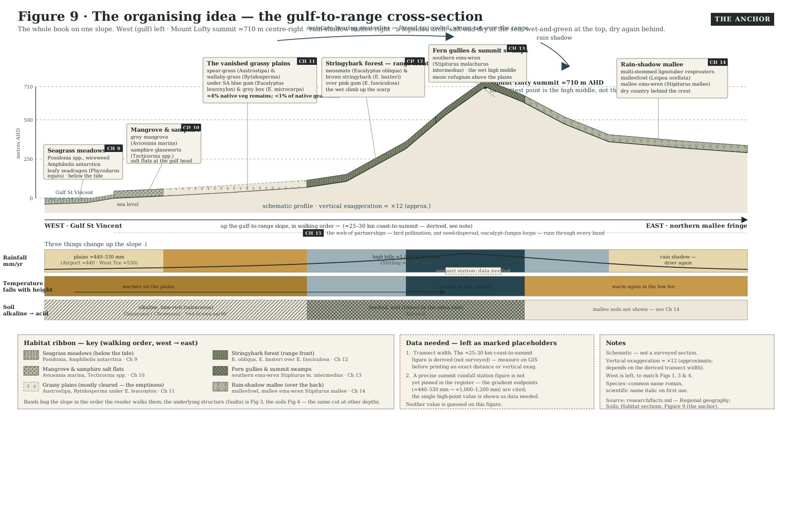
Annotated west-to-east cross-section of the Adelaide region running from Gulf St Vincent up to the Mount Lofty summit and down into the rain-shadow mallee, with habitat bands for seagrass meadows, samphire and mangrove, the vanished grassy plains, stringybark forest, summit fern gullies and swamps, and mallee, plus reference strips below for rainfall, temperature and soil.
Figure 9 · The anchor · gulf-to-range-cross-section "The whole book on one slope. Slice the Adelaide region open from the floor of the gulf to the summit of Mount Lofty and stand the cut face up, and its living communities sort themselves out along a single short, steep climb — salt and dry at the sea, wet and green at the top, dry again in the rain shadow behind. Read the gradient and you can read the country. Everything from here is a walk down it."

Vertical exaggeration; schematic, not to a surveyed scale. This is Chapter 8's figure, The organising idea — the framing chapter for the book's whole third act.

The figure programme

Every other figure, by act

The book's figures share one visual language — west always on the left, blue for water, gold for drought, red-brown earth for rock and emphasis, sage for vegetation — and every one of them is subordinate to the cross-section above. Grouped here by the four acts of the causal braid, in the order the book builds its case.

Act I · deep time built the stage

Rock, faults and the deep past
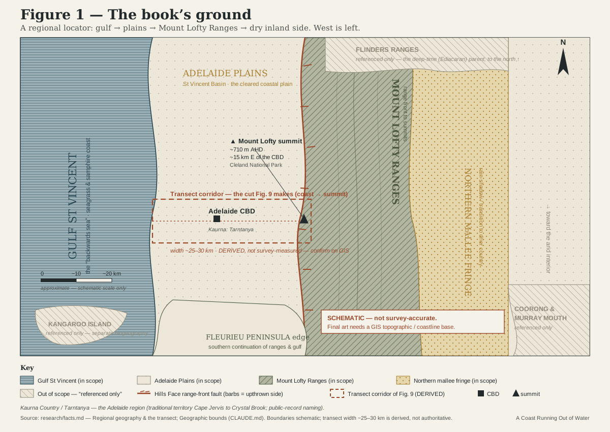
Schematic locator map of the Adelaide region: Gulf St Vincent on the west, the Adelaide Plains, the Mount Lofty Ranges as an upland spine, the Fleurieu Peninsula to the south, and the northern mallee fringe behind the ranges, with Kangaroo Island, the Coorong and the Flinders Ranges greyed at the edges as out of scope.
Figure 1 · regional-locator-map "The book's ground: the Adelaide region read as a single climb from Gulf St Vincent, across the plains, up the Mount Lofty Ranges and down their dry inland side. Kangaroo Island, the Coorong and the Flinders Ranges (greyed) lie outside the frame and are touched only where they enter the story."
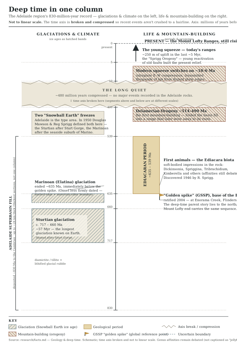
Vertical stratigraphic timeline of the Adelaide region from about 830 million years ago to the present, marking the Sturtian and Marinoan glaciations, the Ediacaran dawn of animal life, the Delamerian mountain-building, and the young uplift that raised today's ranges.
Figure 2 · deep-time-timeline "Eight hundred million years on one page. The rocks behind Adelaide record two of the deepest freezes the planet has known, the first stirrings of animal life, an ancient range that wore away to its roots — and, almost yesterday in this company, the young squeeze that pushed the present hills back up."
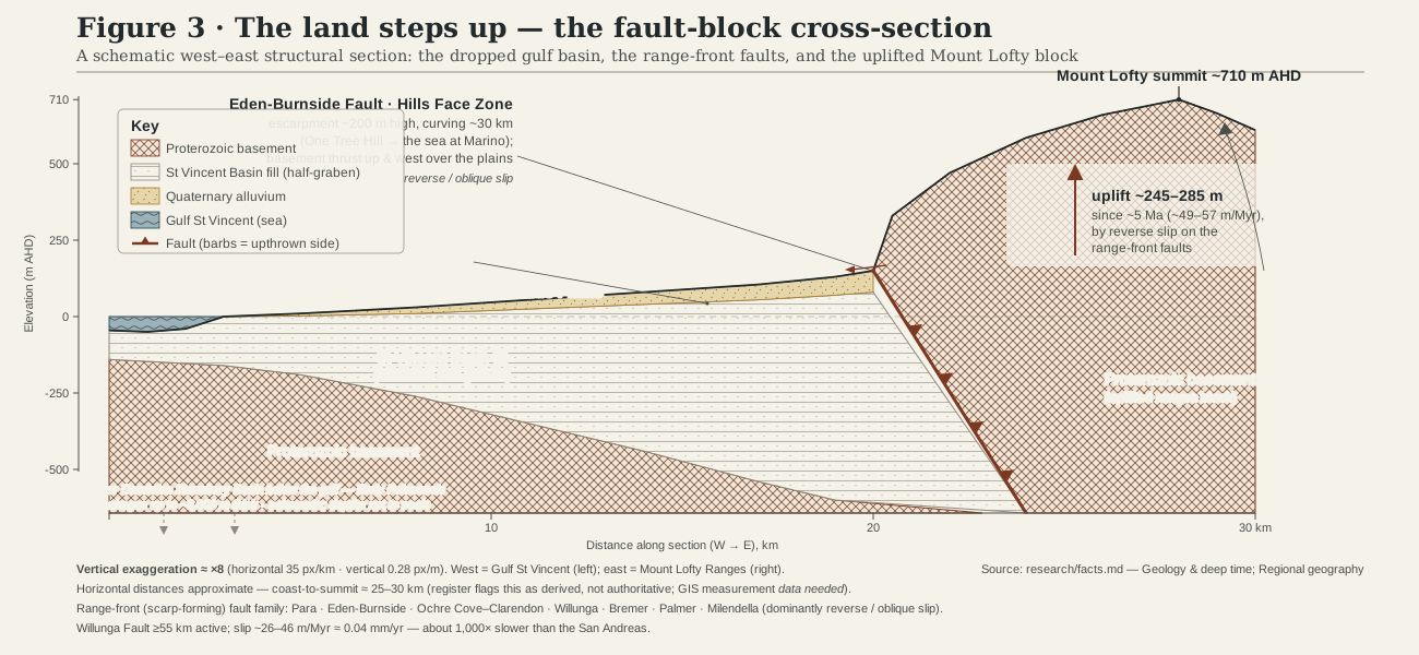
Structural west-to-east cross-section showing a dropped Gulf St Vincent basin beside an uplifted Mount Lofty Ranges block, separated by range-front faults including the Eden-Burnside Fault, with old basement rock thrust up and over younger plains sediments.
Figure 3 · rift-fault-block-cross-section "Adelaide sits on a dropped block; the hills are an uplifted one. Along the range-front faults — the Eden-Burnside among them — old basement rock is being shoved up and westward over the young plains, raising the ranges by tens of metres every million years. The escarpment you see from the city is the torn edge of that machine."
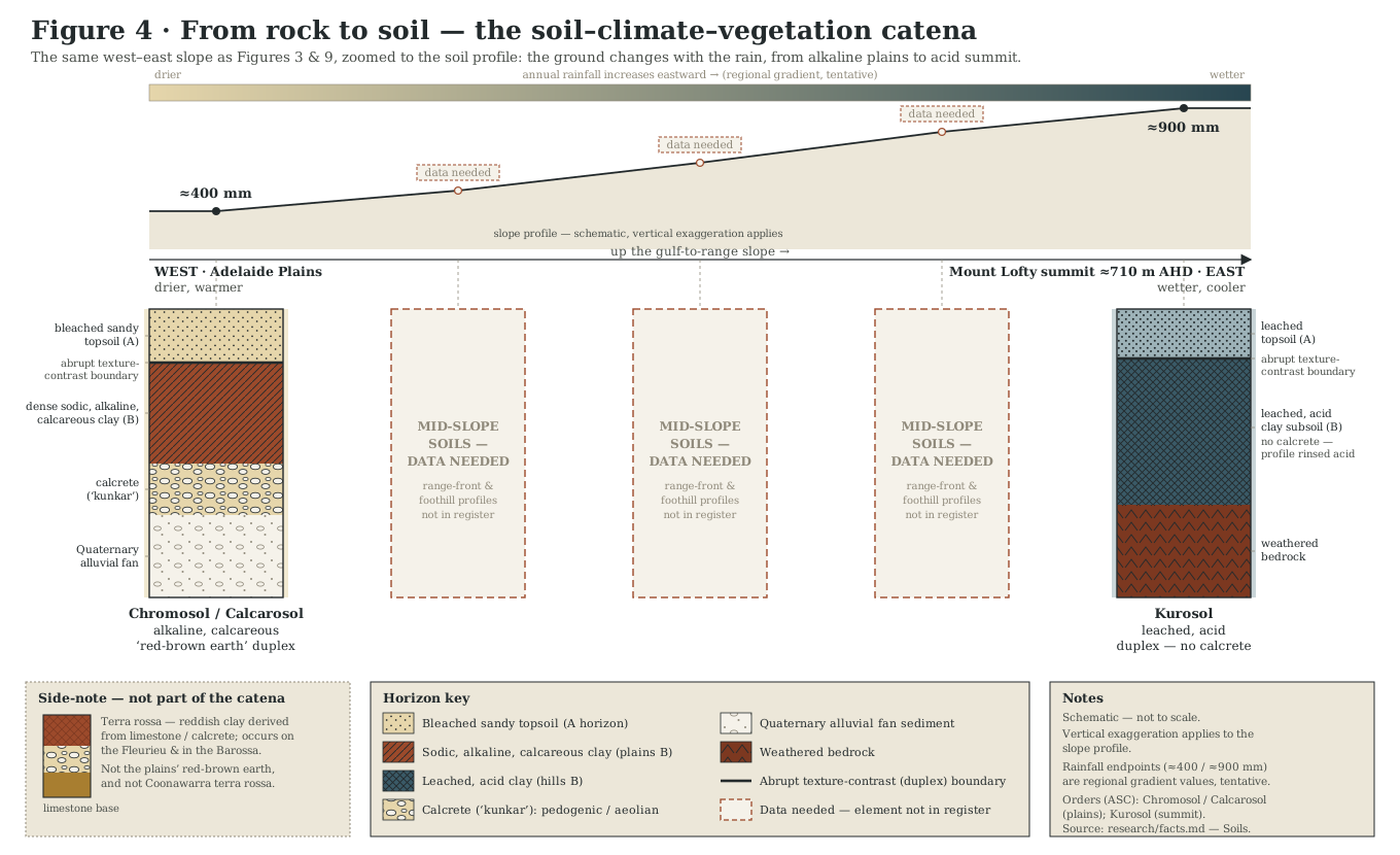
Schematic cross-section of soils along the gulf-to-range slope, from alkaline calcareous red-brown earths over sheets of calcrete on the dry plains to leached, acid soils in the wetter Mount Lofty Ranges.
Figure 4 · soil-catena-cross-section "Climb the slope and the ground beneath your feet changes with the rain. On the dry plains the lime never washes out, so the soils stay alkaline and salty over sheets of buried carbonate; only in the wet hills does the extra rain finally rinse the profile acid. Soil, like everything else here, is arranged along the gradient."

Act II · the drought engine sets the rules

A globally rare bargain with the seasons
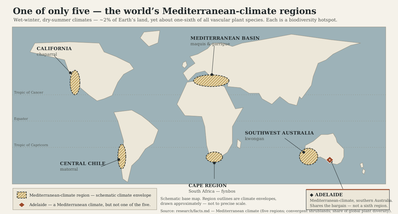
World map marking the five Mediterranean-climate regions — the Mediterranean Basin, California, central Chile, South Africa's Cape region and southwestern Australia — with southern South Australia flagged as sharing the same wet-winter, dry-summer climate.
Figure 5 · mediterranean-climate-world-map "There are only five of them. Wet-winter, dry-summer climates cover about two per cent of the land on Earth, yet each of these five regions is a botanical treasure-house — chaparral, fynbos, matorral, kwongan and the maquis of the Mediterranean itself. Adelaide keeps the same bargain with the seasons, which is why what is cleared here is globally rare."
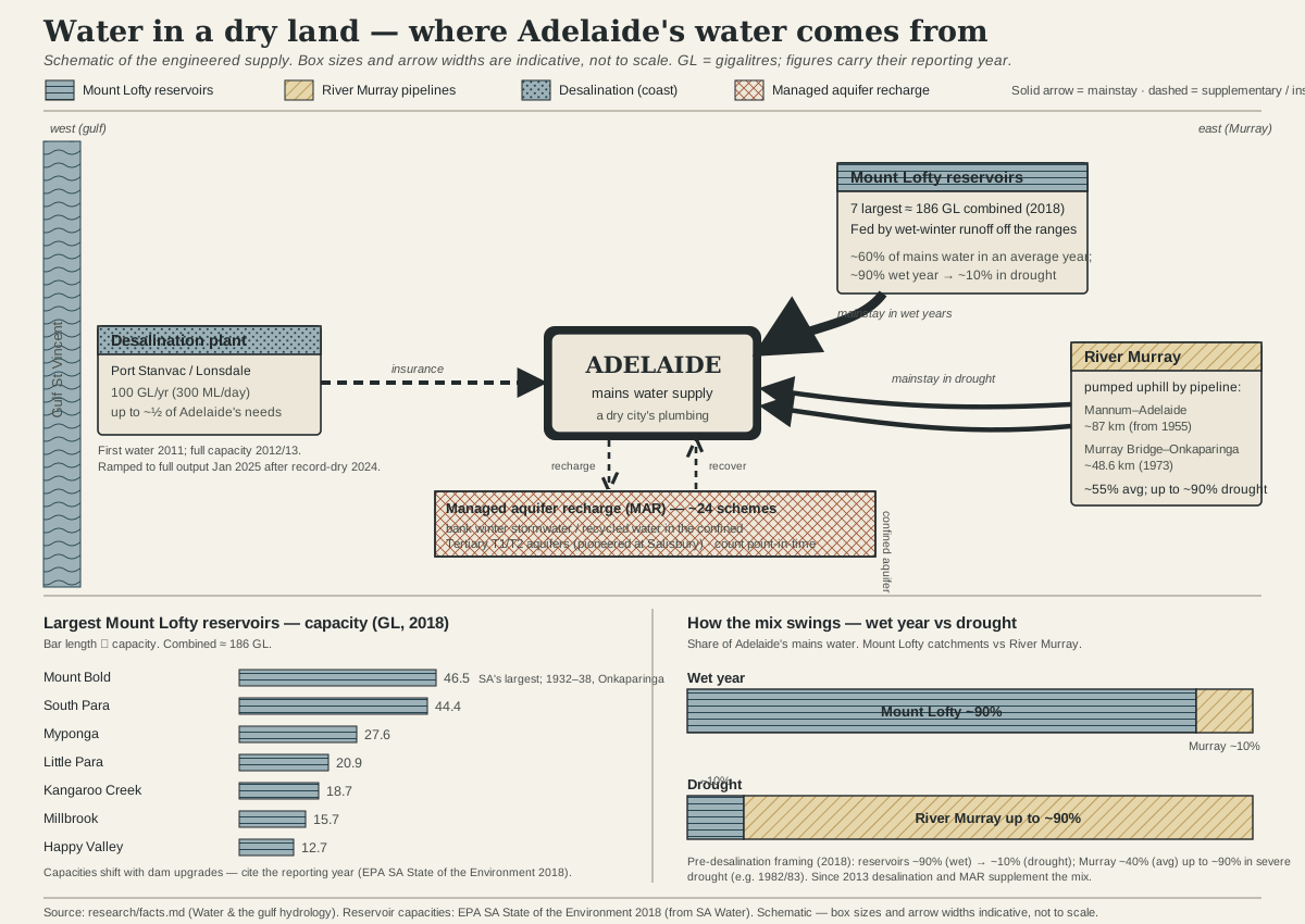
Schematic diagram of Adelaide's water supply system, showing Mount Lofty Ranges reservoirs, River Murray pipelines, the Adelaide Desalination Plant and managed aquifer recharge schemes all feeding the city, with the mix shifting between wet years and drought.
Figure 7 · water-sources-schematic "A dry city's plumbing. In a wet year the Mount Lofty reservoirs can supply most of Adelaide's water; in a drought that share can fall to a tenth, and the Murray — pumped uphill through pipelines since the 1950s — makes up the difference, with the desalination plant and banked stormwater as insurance. The mix moves with the rain."
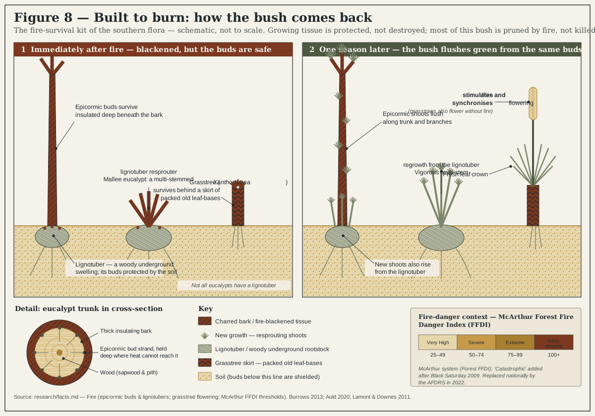
Cutaway diagram of fire-survival mechanisms in the southern flora: a eucalypt resprouting from epicormic buds and a lignotuber, and a grasstree flowering behind its insulating skirt of packed leaf bases after fire.
Figure 8 · fire-response-diagram "Most of this bush is not killed by fire; it is pruned by it. Eucalypts keep spare buds hidden deep under the bark and in a woody underground swelling, the lignotuber, and flush green from them within weeks. A grasstree shrugs off the flames behind a skirt of its own packed old leaves and then, cued by the burn, sends up a flowering spike. Fire here is not an accident. It is the routine."

Act III · the living gradient demonstrates the rules

Beyond the anchor: two more slices of the slope
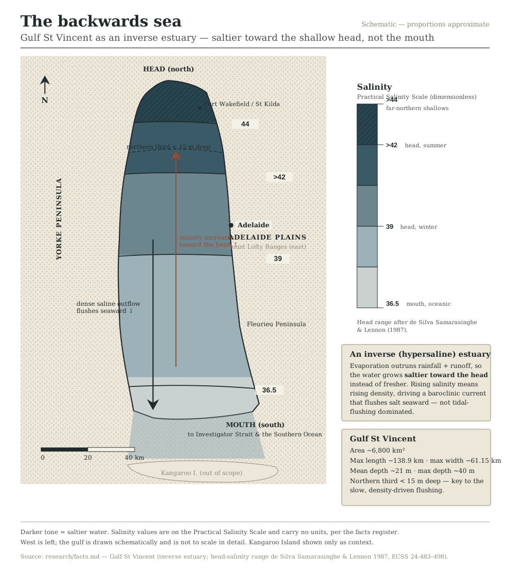
Map and gradient chart of Gulf St Vincent showing salinity rising from ocean-normal at the mouth to hypersaline at the shallow northern head, illustrating the gulf's behaviour as an inverse estuary.
Figure 10 · backwards-sea-salinity-gradient "A sea that runs backwards. In Gulf St Vincent the sun lifts off more water than the rivers and rain put back, so the gulf grows saltier the further in you sail — from ocean-normal at the mouth to well above forty at its shallow head. Oceanographers call it an inverse estuary; it is one of the reasons the gulf is such a singular place."
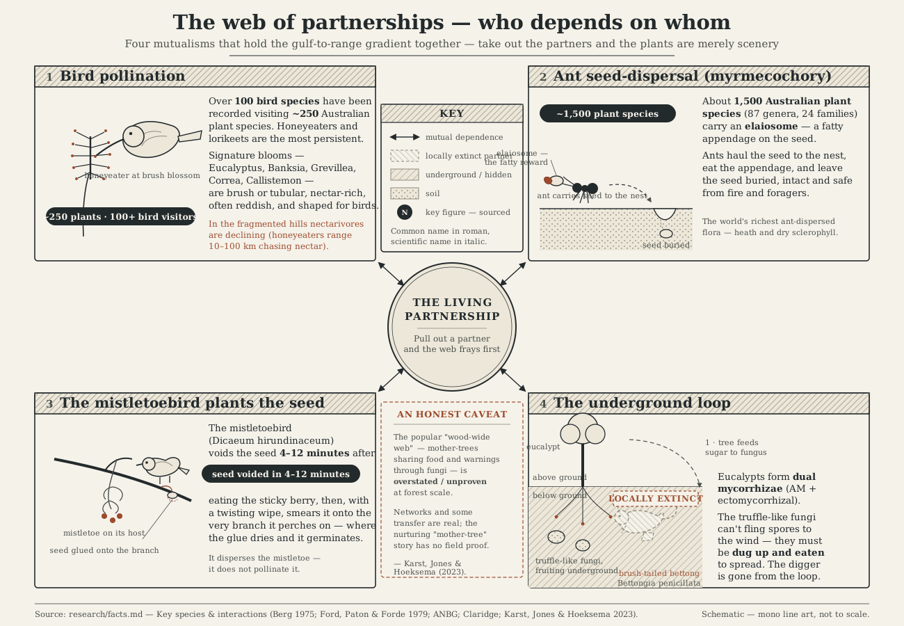
Diagram of ecological partnerships in the Adelaide region drawn as linked vignettes: bird pollination, ant seed-dispersal, the mistletoebird planting mistletoe, and the underground eucalypt-fungus-digging-mammal loop.
Figure 14 · mutualism-web-diagram "The plants of this country do not stand alone. Birds carry their pollen, ants plant their seeds, a small bird glues mistletoe to the very branch it will grow on, and underground the eucalypts trade sugar with fungi that can only spread when a digging marsupial eats them. Pull out the partners and the forest is just scenery — which is why, in a fragmented landscape, the web is what frays first."

Act IV · the great clearing, and caring for Country

Reading absence, made visible
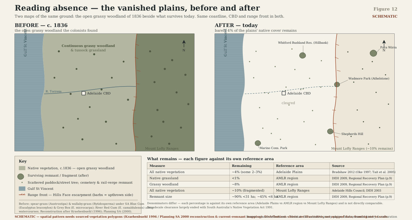
Paired before-and-after maps of the Adelaide Plains and range front: pre-1836 grassy woodland and grassland reconstructed on the left, and the sparse fragments of native vegetation surviving today on the right.
Figure 12 · vegetation-clearance-before-after "Two maps of the same ground. On the left, the open grassy woodland the colonists found in 1836 — spear-grass and wallaby-grass under scattered blue gums, reconstructed from the first surveyors' notes. On the right, what is left: barely four per cent of the plains' native cover, clinging to cemeteries, rail verges and the odd paddock tree. Reading the plains today is less botany than detective work."

This is the book's "reading absence" thread at its most literal: not a lament, but a detective act.

A paddock, a street tree, a fence-line remnant is read for what it is the last trace of. The percentages behind this figure — roughly four per cent of the plains' native vegetation surviving, less than one per cent of its native grassland — carry different reference areas depending on the source, which is exactly the kind of figure this book's method insists on labelling carefully rather than rounding to a tidy headline.

Three figures in the programme are still to be drawn. Goyder's Line (the 1865 survey marking where reliable cropping rainfall ran out), the East Asian–Australasian Flyway map (tracing Gulf St Vincent's shorebirds to their Arctic breeding grounds), and the Mount Lofty rainfall island (the metro-scale view of the same wet-hills-dry-plains pattern the cross-section shows in profile). They will join this gallery once they exist.

Follow the writing

One email, when there's real news

No countdown, no sales pitch — just a note when a chapter reaches a real milestone, or when the book itself is ready to read.

Free. No spam. Unsubscribe any time.