Field Companion
Take the book with you
A five-stop reading of the gradient, a sample of the species checklist, and a taste of the glossary — extracted from the book's back matter, for the drive, the walk, or the lookout.
How to use this page
A field skill,
not a chair skill
Everything in this book has been building toward one ordinary act: standing somewhere on this coast and reading it for yourself.
The book's closing chapter, "Reading the Country Yourself," folds the whole argument into a portable method. This page borrows three things from the manuscript's back matter to help with that: a condensed version of the book's five-stop reading of the gradient, a sample of its species checklist, and a sample of its glossary. Each is an extract — the full versions are longer, and live in the book itself.
A book about a place is only a set of instructions; the place itself is waiting outside, and it is far better company.
The five-minute reading
Gulf to summit, in five stops
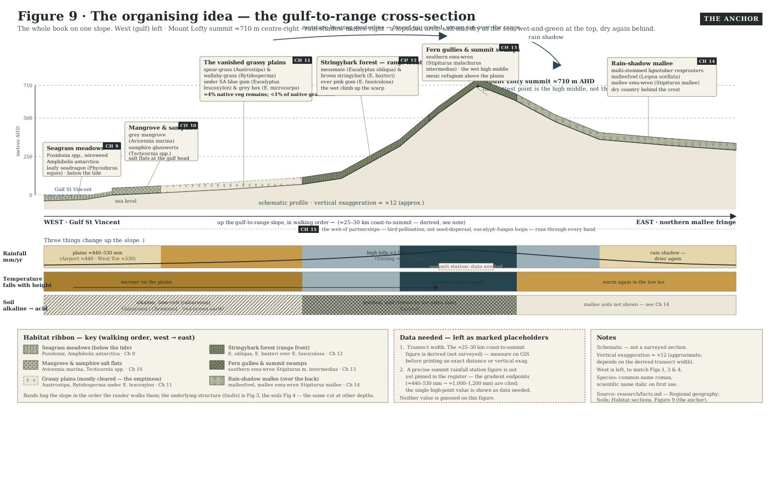
The book's closing chapter folds itself into one routine, run in the order the land was built — from the sea, up over the ranges, and down the dry side behind. It's the same afternoon's drive the book opens with, some forty-odd kilometres from the mangroves to a summit a little over 710 metres up. Stand at each change of country and ask what you're looking at.
At the sea's edge
The samphire coast
Dead-flat, grey-green ground the tide floods twice a day. Grey mangroves give way landward to samphire — the low, jointed glassworts that flush red as summer ends — with saltmarsh and mudflat behind, and a gulf that grows saltier the further out you sail.
On the plains
The vanished grassland
Now suburb, orchard, road and rail, this ground was once open grassy woodland. Read it by what's missing — spear-grass and wallaby-grass under scattered gums — and by its survivors: a lone paddock gum, an old cemetery, a fenced-off rail corridor.
At the foot of the hills
The fault in the skyline
The eastern skyline doesn't slope up to the ranges; it rises in a wall, and that wall is the Eden-Burnside Fault — an escarpment roughly 200 metres high, where ancient basement rock is still being thrust up over the young sediment of the plains.
Up in the wet hills
Stringybark country
Climb the scarp and the country turns cool and damp — the hills catch roughly twice the plains' rain. Tall, fibrous-barked forest takes over, a mesic refugium holding koalas, bandicoots and honeyeaters, increasingly marked by drought dieback.
Over the back
The mallee behind
Cross the summit into the ranges' rain shadow and the eucalypts change shape, growing low and many-stemmed from a woody underground lignotuber. Look for spinifex between the stems, and, if you're lucky, a malleefowl tending its mound.
From the back matter
The named cast, gulf to mallee
The book's full species checklist gathers every plant, animal, fungus and fossil it names, grouped by taxon and by where you meet them on the gradient — including groups not shown here, such as fungi and mycorrhizal partners, and introduced species. This is a sample of it, common name first, with the scientific name where the book gives one.
Trees of the plains and hills
River Red Gum — Eucalyptus camaldulensis — along the watercourses.
SA Blue Gum — Eucalyptus leucoxylon — grassy woodland of the plains.
Pink Gum — Eucalyptus fasciculosa — Mount Lofty sclerophyll forest.
Messmate Stringybark — Eucalyptus obliqua — Mount Lofty forest.
Mallee eucalypts
Red mallee — Eucalyptus socialis
White mallee — Eucalyptus dumosa
Yorrell — Eucalyptus gracilis
Ridge-fruited mallee — Eucalyptus incrassata — the rain-shadow country behind the ranges.
Coast and samphire flats
Grey mangrove — Avicennia marina — the only mangrove in South Australia.
Shrubby Samphire — Tecticornia arbuscula
Samphire / glassworts — Tecticornia spp. — the saltmarsh landward of the mangroves.
Posidonia — Posidonia spp. — the dominant meadow-forming seagrass of the gulf.
Birds of the coast and ranges
Slender-billed (Samphire) Thornbill — Acanthiza iredalei rosinae — endemic to SA samphire saltmarsh.
Mount Lofty / Fleurieu Southern Emu-wren — Stipiturus malachurus intermedius
Yellow-tailed Black-Cockatoo — Zanda funerea
Mistletoebird — Dicaeum hirundinaceum — disperser of mistletoe seed.
Mammals
Southern brown bandicoot (eastern) — Isoodon obesulus obesulus — the only surviving bandicoot of the Mount Lofty Ranges.
Greater bilby — Macrotis lagotis — once common around Adelaide, now gone from settled southern SA.
Koala — introduced to Kangaroo Island and translocated to the Mount Lofty Ranges.
Deep-time fossils (Ediacaran biota)
Dickinsonia
Spriggina — bilateral, ~5–6 cm.
Tribrachidium — tri-radial disc, ~5 cm.
Kimberella — mollusc-like.
Nothing has been added here that the book doesn't itself name — this is a sample of a longer list. Source: manuscript/back-matter/species-checklist.md.
From the back matter
A dozen terms worth knowing
Plain, one-line definitions of technical terms the book uses, arranged alphabetically in the manuscript. Where a term has a looser everyday sense, the definition here is the one the book means. This is a sample of a longer, A-to-Z glossary.
Aeolian
Carried or laid down by wind; the plains' calcrete dust and the mallee's dunes are both aeolian.
Calcrete (kunkar)
Sheets of hard secondary carbonate cemented into the soil, built largely from wind-blown carbonate dust in the Ice-Age dry spells — not marine limestone.
Diamictite (tillite)
Lithified glacial debris — unsorted rock in a fine matrix — the rock record of the Snowball Earth glaciations.
Dodge tide
The day or more, around neap tides, when Gulf St Vincent's twice-daily tide almost vanishes as two tidal rhythms cancel; Matthew Flinders called it "the dodger."
Ectomycorrhiza (ECM)
A fungus that sheathes a tree's fine roots and trades soil nutrients for sugar; the dominant root partnership of adult eucalypts.
Elaiosome
The fatty appendage on a seed that bribes an ant to carry it home, eat the appendage and leave the seed intact to grow.
Epicormic
Of the buds sunk deep beneath the bark that let a burnt eucalypt resprout leaves along its trunk and branches.
Inverse estuary
An estuary that runs the wrong way: evaporation outpaces river inflow, so the water gets saltier from mouth to head. Gulf St Vincent is one.
Lignotuber
A woody swelling at or just below ground level, packed with dormant buds, from which a burnt eucalypt (especially a mallee) can resprout.
Mesic refugium
A moist pocket that stays wet enough to shelter species from the drying country around it; the Mount Lofty forests are one.
Sclerophyll
Hard, leathery, evergreen leaves, and the vegetation built from them; an adaptation to drought and poor soils as much as to fire.
Shifting baseline syndrome
The trap by which each generation takes the depleted nature it inherited as "normal," so long-run loss goes unnoticed.
Source: manuscript/back-matter/glossary.md.
An extract, not the whole companion. The species checklist, glossary and "Reading the Country Yourself" chapter this page draws on are first-draft back matter, still being checked against the book's facts register. Field conditions — access, tides, weather, park rules — change constantly; treat what you find on the ground as the last word over anything printed here.
Follow the writing
One email, when there's real news
No countdown, no sales pitch — just a note when a chapter reaches a real milestone, or when the book itself is ready to read.
Free. No spam. Unsubscribe any time.