About the book
Why Adelaide, why this way, and why you can trust the numbers
The idea, the ground it covers, and the method that keeps a book with no compiler factually honest.
The idea
The most legible
collision in the country
Adelaide is the most legible collision of deep time, drought and clearance of any Australian capital — a place where the whole story of a landscape can be read in a single afternoon's drive.
In under an hour you can go from salt water to a summit that catches roughly twice the plains' ration of rain, and every living thing along that short, steep slope has arranged itself around surviving the gap. The book reads that arrangement in the order it was built, not as a grab-bag of nice facts about nature near Adelaide.
Four forces braid into one argument. Deep time built the stage: the ranges behind Adelaide are the southern end of the Adelaide Rift System, and the land steps up from a dropped gulf basin to an uplifted ranges block along faults that are still active. A Mediterranean summer-drought climate wrote the rules — wet winters, killing-dry summers, one of only a handful of such climates on Earth, and every one of them a global biodiversity hotspot. That gives the book international stakes: what gets cleared here is globally rare habitat, not a merely local loss. The living gradient demonstrates the rules — Gulf St Vincent's seagrass and samphire, up across the Adelaide Plains, up the range front to the Mount Lofty summits, and down into the rain-shadow mallee behind. And a city rewrote the surface: Adelaide sits on one of Australia's most heavily cleared, most peri-urban landscapes, so reading its ecology means reading rock, drought and absence at once — then restoration, and people.
Deep time built the stage.
Drought wrote the rules.
A coast running out of water.
The "reading absence" thread that runs through the book's last act is never abstract lament — it's detective work: reading a paddock, a street tree or a fence-line remnant for what it is the last trace of.
The ground
Gulf to range, and no further
The book's territory is a single transect, not a whole state. Everything in it earns its place by sitting somewhere along the line from the gulf floor to the range top and the mallee behind.
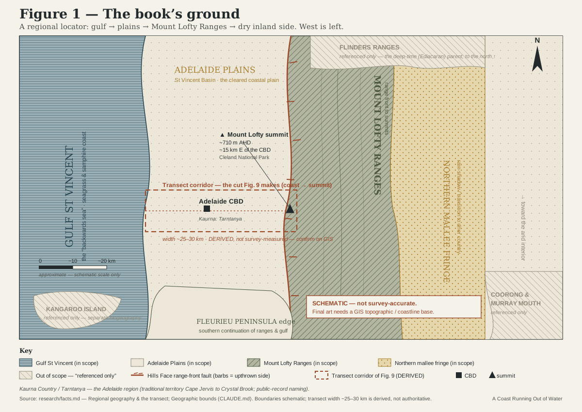
In scope. The Adelaide Plains and St Vincent Basin — the coastal plain the city sits on. The Gulf St Vincent coast — metropolitan beaches, seagrass meadows, samphire and mangrove, the Port River estuary. The Mount Lofty Ranges — the range front and its faults up through the Adelaide Hills to the summits. The Fleurieu Peninsula edge, as the southern continuation of the ranges and gulf systems. And the northern mallee fringe — the rain-shadow transition to drier country behind the ranges.
Out of scope, referenced only where they touch the story. Kangaroo Island has a separate biogeography and sits outside the transect entirely. The Coorong and Murray Mouth are touched only where they connect — migratory shorebirds, the gulf's link to the Southern Ocean — never covered in their own right. The Flinders Ranges proper appear only as the geological parent of the deep-time, Ediacaran story; the book's living ground is the Mount Lofty end. The far arid interior, the Murray/Riverland valley and the South-East are out except as context.
How it is kept honest
A book has no compiler — so we built one
Prose doesn't fail loudly the way code does. Nothing mechanically tells you a figure is wrong, a source is invented, or the voice has drifted. So the project builds those checks by hand.
The register
One canonical fact, stated once
Every figure, date, name and status that recurs across the book — an earthquake magnitude, a clearance percentage, a fault name — is resolved in a single canonical facts register before it is allowed to appear in prose. When two places disagree, the register wins.
Cite or cut
Every load-bearing claim is sourced
A number goes into the register with its source attached, and a flag for anywhere the evidence is contested or still unconfirmed. If a claim can't be traced to a source, it doesn't go in the book — however good it would sound.
Tone is licence, facts are not
Wit is free; invention is not
The book is written in a warm, accessible voice — but that licence covers telling, never truth. No invented anecdotes, quotes or biography about real people, living or dead, and no manufactured colour standing in for a fact that isn't there.
The Kaurna protocol. This is an ecology-focused book, and cultural content is touched on lightly and respectfully rather than made a major theme. It acknowledges the Kaurna people as the Traditional Owners and continuing custodians of the Adelaide Plains (Tarntanya), drawing only on published, public-record sources — regional and linguistic histories, government and museum records, the reconstructed Kaurna language work, and the documented record of Aboriginal land management with fire. Nothing is invented, embellished or presented as canonical: where a detail would need cultural knowledge and no published, properly attributable source exists, it is left out rather than fabricated. That's how the book stays respectful without engaging custodians directly, which isn't presently possible.
Work in progress. The full first draft of all eighteen chapters is complete. The manuscript is still being checked, chapter by chapter, against the canonical facts register before anything is called final — and it is not yet published or for sale.
The person behind it
Written by Daniel Addington
A short, honest note on who's writing this and why — no invented credentials, no borrowed authority.
Follow the writing
One email, when there's real news
No countdown, no sales pitch — just a note when a chapter reaches a real milestone, or when the book itself is ready to read.
Free. No spam. Unsubscribe any time.